The geophysical applications in engineering include those in geotechnical engineering, civil engineering, offshore drilling, offshore cable and pipeline route selecting, tunneling, transportation, and construction.
Faults and fractures may act as failure planes in landslides, and water bearing zones or conduits that may cause problems in tunneling.
Lava tube and mine working locating
Near surface lava tubes and mine workings may collapse and become hazards. The strong density, velocity, dialectical, magnetic remanence, and resistivity contrasts between the air/water-filled voids and surrounding soil/rock make them detectable with gravity, seismic, GPR, magnetics, and EM and electrical resistivity imaging methods.
A GPR profile over lava tubes
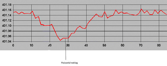
A micro-gravity profile over a mine working
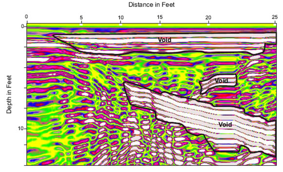
Karst features and voids
A common concern for property developments and highway foundation in limestone or chalk environments is the possible presence of hidden solution features or voids. The need to fully characterize potentially unstable ground in these environments is critical during the planning stages of a project.
Solution features and voids are commonly mapped using GPR, electrical resistivity imaging, time/frequency-domain electromagnetics, and micro-gravity. The determining factors on the suitability of a particular geophysical technique in mapping voids and caverns are their anticipated depth and spatial extent, as well as the conductivity of the host material.
Tunneling
The common geophysical applications in tunneling are to determine the followings:
The presence of voids and water behind concrete liner;
The rock modulus and thickness of the elapsed zone after blasting;
The depth to the bedrock and rock rippability
The soil shear strength
Fault zones
Permafrost mapping
The presence of permafrost and its thickness are significant concerns for utility corridor planning in northern regions. The application of geophysical methods in utility corridor selection may include the mapping of ice-bearing soils in discontinuous permafrost zones, mapping of thaw zones in more continuous permafrost and estimation of ice-content. Commonly used methods include electrical resistivity imaging, electromagnetics, seismic reflection, and GPR.
Rock rippability
Rippability is the ease with which soil or rock can be mechanically excavated. According to Bieniawski, rippability of rock is assessed by numerous parameters including uniaxial strength, degree of weathering, abrasiveness, and spacing of discontinuities. Nevertheless, seismic refraction has historically been the geophysical method utilized to indirectly predetermine the degree of rippability.
Ripping is typically performed by tractor-mounted equipment. The size of the tractor (dozer) is determined by the ripping assessment of the rock. The hardness and competency of each individual material will determine the ease of rippability. Rock that is too hard to be ripped is fragmented with explosives.
The rock rippability can be estimated using compressional seismic wave velocity, which can be obtained with seismic refraction.
Depth to bedrock
The information of the depth to bedrock is critical in utility route selection studies and foundation design. The common techniques are seismic reflection, seismic refraction, electrical resistivity imaging, electromagnetics, gravity, and GPR.
Underground utility locating
The underground utility locating is widely used in construction, provides critical information of the location and depth of underground utilities. Underground utilities include power lines, metal or PVC water pipes, steel gas pipelines, fiber optic cables, telephone cables, and storage tanks. Magnetometer, radio detection, GPR, EM61, and pipe locators are commonly used.